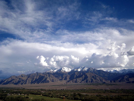
Himalayas mountains
Treks in Ladakh region are very popular due to one of the most amazing mountain views that can be seen on Earth combined with the fact that most of the walking is done at 4000 m. above sea level (13 100 feet). It is common to book a trek with a local travel agency that includes horses or donkeys that carry one’s luggage, a local guide and a cook. The price also includes food, jeep transportation for all the journey from the starting point to Leh. Nights are spend at tents (your own or one that the agency provides) or at people’s houses – homestay.
In this way one carries no more than 3 kilos of luggage and is free of worries. The price is around 400 euro per person depending on the number of the people enlisted. Very few are the people who go in these mountains by themselves and we have written this article exactly for them. We encourage people to organize expeditions by themselves in order to have a brand new experience unique to them.
It is almost impossible to get lost because the pathways are so well beaten that you don’t need a guide. You will have to carry 15 kilos of luggage on your back of course, but that shouldn’t be a problem for any mountaineer. Another thing is that many people get frustrated with the rhythm of the horses and donkeys, namely that you must comply with the program of the agency because the animals always go ahead of you. So let’s say you want to walk 3 instead of 7 hours – in this case it is not possible because the animals carry everything and will reach the next stop before you and you can’t tell them you’ve fallen behind.

Our bivouac
If you want to pitch your tent at a place you like you can’t do this either because you have to stay at a camping site with all the other tourists. It also happens for the horses to fall behind. In this case you have to go 2-3 hours back.
Here are some important information that will serve all who decide to plan their treks by themselves. First and most important is that this is not a walk in the park. You will be walking in one of the most raw and harsh mountains on Earth – the Himalayas. You need to have mountain experience and be in good physical condition. Do not underestimate the mountain – this could be very dangerous!
- Getting oneself informed before the trek: Before you start you need to research all the information at the local tourist agencies. Those in Leh are very well informed. Ask for: the situation with the bridges you will cross (sometimes bridges over big rivers get carried away); landslides; how much snow there is (usually in July/August all the snow below 5200 m. (17 060 feet) had melted); glaciers (treks that cross glaciers are few); what to do in emergency situations.
Inform yourself how many days the trek you’ve chosen is, how many hours per day you have to walk, how many passes you will cross and what their altitude is. Detailed information of all the treks is available in Internet. You can also print a map and a description.

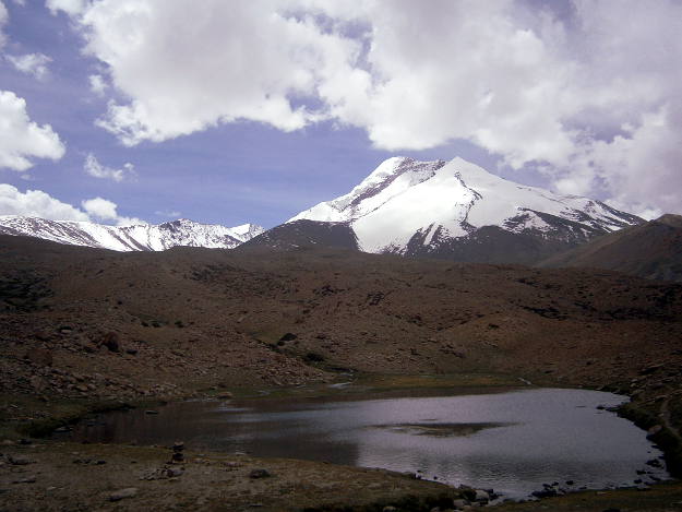
Hanuma La Pass
– Maps: you must have in mind that on 90% of the treks there will be no electricity in the villages you pass through so consider this and the electronics you will rely on. The best thing to do is buy a paper map from the bookstore. Good, detailed maps are not so much and the most important is for them to have topography. The best map we could find (and the only one with topography) is of the Milestone Himalayan Series called “Ladakh and Zanskar trekking map”, of the scale one to one hundred and seventy thousand. It costs 8 dollars.
It can’t be found at all the bookstores at Leh, but you can find it for sure at the touristic part. At the bookstores you can also find many books in English with detailed information of all the treks in Ladakh. The old maps printed in black and white, which have topography, are wrong – for example the length of the different parts of the trek is not correct or the villages are misplaced. Don’t buy them!
It is also good to have a compass on you.
- Equipment: You all know that it is important to be well equipped. Don’t forget to take with you: comfortable mountain shoes; thick clothes for the bivouacs above 4500 m. (14 800 feet) where temperatures may fall below minus 5 degrees Celsius (23 Fahrenheit); jacket for rain (it rains a lot though everyone say it is a dry region); cap and sun protection cream (the sun is very strong at this altitudes); thick sleeping bags and a comfortable rucksack.

It is also good, but not necessary, to have: sandals (they are great to have when you need to cross a river 20 times a day); sunglasses; gloves. It is quite hot during the day, but when it rains and at night it gets very cold, so you have to consider well how many and what types of clothes to take with you.
- Food, water and cooking utensils: You have to assess very well the quantity of the food you take with you based on the days you will walk – it is good to take a little bit more than you calculated you would need. Most of the treks’ paths pass thorough villages and camp sites, but have in mind that the villages consist of just 4-5 houses and usually there is no shop and you can buy at most flour, lentils and rice from the people, but their resources are also quite limited.
When there is a shop at the village they usually sell only biscuits and instant noodles. The situation at the camp sites is similar because tourists go with horses and carry their own food. So the best thing to do is buy all you need from Leh.

How to make tea
There is water in almost all of the villages and there are many springs near the paths. The water from them is perfect and you don’t need bottled water. Some of the springs are hard to see but if you see a trickle of transparent water sipping through the rocks you can drink it.
It is best to fill the bottles you carry with you whenever possible because you can sometimes walk for 2-3 hours without seeing any spring. We are two people and have a 1,5 l. bottle which is perfect. When you cook you can look for a spot next to the camp sites or next to clear springs or brooklets.
– Cooking utensils: we bought a small kerosene cooking stove (you can find them everywhere in India) that was essential to us in Ladakh region. It is practically impossible to light fire here because there is no wood. Gas stoves are not good choice either because sometimes it is hard to find gas cylinders.
Our kerosene stove weighs quite a lot, but there are also smaller ones. You can usually find them at the markets near the bus stations. The main benefit is that here they sell diesel or kerosene everywhere even at the small, remote villages. Cooking every day we use 3 liters per ten days.
Here are some exemplary foods we bought for the treks: rice, lentils, pasta, instant noodles (mainly as a reserve), flour (for chapatas – flat bread and fried batters – they are very delicious with yeast), vegetables (ONION – very important for almost all meals, garlic, peas, okra, eggplants – they don’t weigh much), cooking oil, spices (masala), sugar, white cheese – paneer (1,5 kg.), biscuits, yellow cheese.
Here are some of our additional secret products: flat bread from the Kashmiri people (20 pieces), they are enough for preparing sandwiches for a week, condensed milk (this is our white chocolate) jam (which we put in a plastic bottle because of the weight), dried apricots and raisins (you can put the apricots in water for some time and they become almost as the fresh ones), lime with sugar (our favorite source of vitamin C), tea, tsampa (baked Tibetan flour that is great for morning shake), 3 packs of butter (important source of calories), nuts (mostly peanuts).
We’ve seen that other trekkers have oatmeal, peanut butter (which is quite expensive here), precooked soups (also expensive).
Work out how much you will eat per day. Don’t carry too much. During the first days your rucksack will weigh a lot, but like this you will exercise your body and have a balanced diet.
Useful culinary advices:
- Put salt on the paneer to last longer
- If you want to drink fruit juice mix jam with some water
- Don’t buy chocolate – it melts from the heat, substitute it with chocolate biscuits, condensed milk or Nutella
- Fry the peanuts yourself – it is very delicious
- Don’t buy too much lentils, it takes long time to get cooked
- Boil eggs for proteins – they last longer when boiled
- Lime here is cheap and doesn’t weigh much, it’s delicious with sugar – good source of vitamin C
- Use only plastic bottles instead of jars and glass bottles
- If you make chapatas – flat bread, or similar with flour, use yeast, it is more delicious. You don’t have to wait for the dough to rise, just leave it for ten minutes. The difference in taste is great, you’ll see.
- Always have half a liter of kerosene in a plastic bottle with you as a reserve
- Meals are cooked faster and are more delicious if you put a lid on the pot – better said they never get cooked without a lid 🙂
Of course this is what we did – you can experiment, buy the things you want and have a unique to you experience
Here are several receipts we did during the treks:
Tsampa – good for breakfast:
Sweet meals: Mix several spoons of tsampa in hot milk, water or tea and add sugar. Stir till you have a homogenous mixture. This is the perfect energy drink.
Salty meals: mix tsampa with water till smooth. Add cheese and butter. Eat with pleasure.
Chapatas – some tourist guides advise the tourists to not carry flour and prepare chapatas because it’s a dirty work. But we think that bread is essential and if you haven’t done chapatas, you haven’t lived : ) In addition chapatas here are small and expensive.
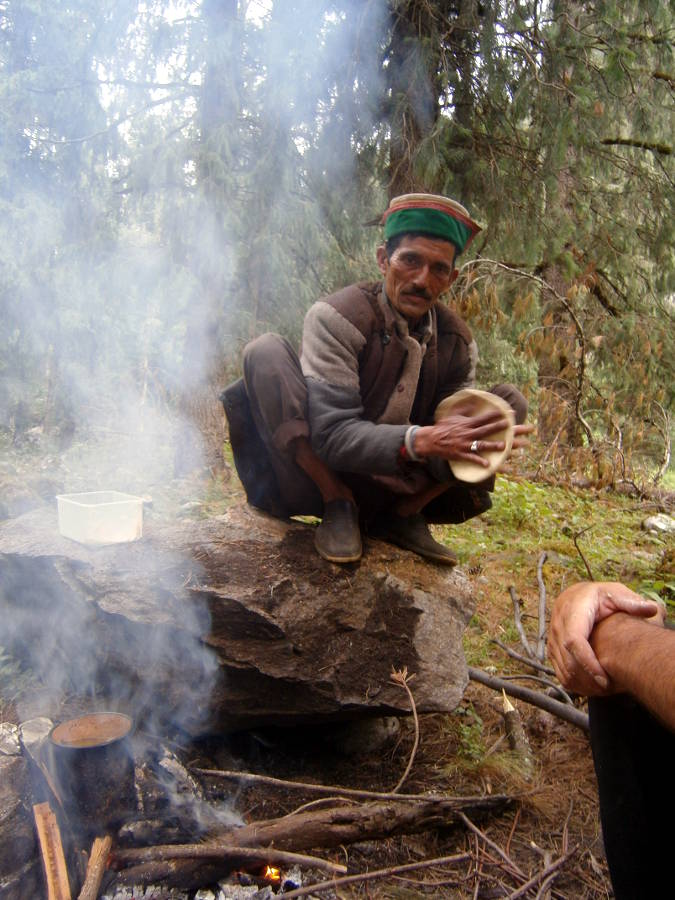
A local who prepares chapatas
The dough: If you already know how to do it you can skip this paragraph. Put 600-700 gr. flour in a bowl, add salt, yeast and start adding water slowly while mixing with one finger till it squashes. Then you sprinkle more flour on top and start kneading with whole hand till it gets hard (but not too hard – think plasticine). The more you knead the better.
The chapatas: it is best to bake them on live coal wood fire (if there are cow excrements even better). Tear some dough and make a ball of 5-6 cm. in diameter (2 inches), make it spherical and then start rolling it with your fingers and making it flat at the same time – make it as thin as you can without tearing holes in it. Then you have to start slapping it on your palms in order to make it evenly thick everywhere. Baking it is fast and easy and you have to be careful to not touch the coal with the chapata because it extinguishes it. Turn them every few seconds in order not to burn them. When the chapata is ready you can put it in cloth or a newspaper. If you don’t have fire you can bake/fry them with some cooking oil on the stove.
Mekitsi (batters): the dough is the same but you have to put more yeast. Fry with lots of oil. You may also put cheese inside and enclose them.
Our own receipts:
Ribbets – make the dough harder. Fry one onion with spices. Add water in it and wait till it boils. Cut the dough into small pieces, roll the ribbets in flour and put them in the water. Wait for 5-8 minutes.
Gypsy pastry – you need some bread. Put oil in a plate, add spices, dip the bread and eat. If you don’t like it you are probably not hungry enough. 🙂
VERY IMPORTANT!!!
Potential dangers to avoid:
– Rivers:
- After 2-3 p.m. the level of all the rivers rises suddenly because of the melted snow at the higher parts of the mountains where their spring is. It is not a good idea to cross the rivers in the afternoon.
- Be careful where you cross the river – the rule is the wider the river it is the more shallow and easy to pass.
- Never ever install your bivouac near the river bank. Levels can rise rapidly after a storm in the mountain that you can’t even see from below.

River crossing

– Landslides:
- Happen more when it rains. If you see fallen landmass or rocks on the path better hurry.
- Don’t pitch your tent near places with fallen rocks even if the place look really attractive.
– Peaks:
Don’t sleep on them because there could be a thunderstorm and you will be on the highest place where lightings may fall many times in just minutes.
– The path:
Paths are well beaten and it is unlikely to lose them. In addition they usually follow the river banks. Passes are easy to be found. In case you are not sure you can always ask local people, other tourist or you can use your map.
– Attitude sickness:
Many tourist have symptoms of altitude sickness when they go higher than 4000 m. (13 100 feet) – these include: headache, nausea, inability to breathe, weakness etc. You can find information in Internet of how to avoid altitude sickness and what to do if you have one.
Be careful! Altitude sickness can be fatal for some people if measures aren’t taken.
Most of the people we met above 4500 m. (14 800 feet) had a headache and difficulty breathing. If symptoms are unbearable just descend 🙂

Yaks under Singi La
– Freezing and burning:
Protect yourself from the sun because it is very strong at these altitudes. Above 4200 (13 800 feet) temperatures fall to -5 Celsius very rapidly (23 Fahrenheit) even in July/August.
General impressions from the treks we did (July/August 2015)
Have in mind that the situation changes all the time because new roads are actively being built and some treks could disappear in a year or two. Landslides and broken bridges could block certain treks and change the path. Sometimes even the newest maps don’t reflect the latest changes.
Advice: Choose treks that have more passes, not the opposite as most people do here, because they prefer their walks to be easier. But namely at the passes are the views that will take your breath away.

Markha Village
1. Markha Valley Trek
The most popular trek in Ladakh. You will meet other tourists and there are many villages and agricultural lands near River Markha’s banks. If you decide to give it a try it’s better to start from Zingchen Village or from Stok Village, where you have to cross two passes. If you start from Chiling village you have to know that the trek is not so picturesque and passes through many villages on the river banks.
It is probably worth it only because of the passes Kanda La, Stok La and Kogmeru La where the views are great, but nevertheless we don’t recommend it so much
Difficulty level: easy, duration – 5-7 days. There is food and shelter everywhere (homestay or camps where you can rent a tent). Prices are high.
2. Lamayuru – Padum (Zanskar trek)
Difficulty level: middle to hard, duration 6-10 days. Nice trek but at least 70% of it will be gone in 2-3 years because roads are being built. The asphalt road goes to Phanjila and the dirt road goes to Yulchung. At the moment the bridge before the pass Singi La on the side of Photoksar Village is destroyed and 90 % of the tourists start from this point because the jeeps can’t cross the river (July 2015). The bridge is being rebuilt.
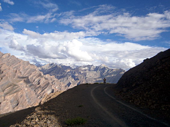
Zanskar Range
In the final leg the dirt road starts after Pidmo village but half of it is taken away by the river and the road between Rinam and Padum is being used.
It’s good to buy enough food and have a tent. There are villages on the road, but sometimes are 5 hours away from each other. There is a shop at Lingshed Village where you can buy things.
The most picturesque places are: Singi La Pass, the path above Yulchung Village, Hanuma La Pass and Zanskar Valley. If you want to be into the wilderness we don’t recommend it so much, but on the other hand the views are breathtaking.
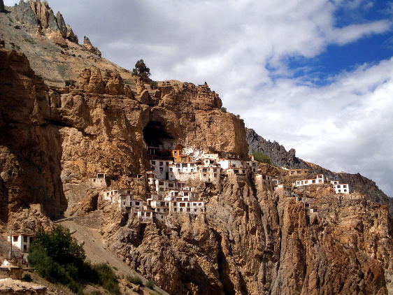
Phugtal Monastery
3. Phugtal Gompa (Monastery) Trek, Zanskar region
Difficulty level: easy, duration 4-5 days. Local transportation: jeeps that reach Reru Village (two-way). There has been a big landslide that cut the road before Ichar Village and further on the road has been destroyed by the river. Now they are building it again. It continues then to Purni.
It is worth it because the monastery is awesome. The path after Anmo gets very picturesque. But be careful! The path goes on only one side of Ichar Village and you can’t cross the river once you step on it. There are dangerous landslides. All the way there are villages and homestays. You don’t need a tent, but there are no shops in the villages.
4.Padum-Darcha: we didn’t do the trek, only the first two days of it. Do it soon, if you want to do it, because they are building a road here too.
5. Rumtse – Tso Moriri
Difficulty level: middle to difficult, duration: 7-8 days. This is an extraordinary trek at the desert like region in east Ladakh. The views are amazing and like nothing you have ever seen. The last day you’ll reach the high mountain lake Tso Moriri which spreads dozens of kilometers.
There is not one single village on the road so you have to carry all the food you’ll need till you reach Korzog at the lake’s shore where there are shops, restaurants and hotels. There is also a bus to Leh. The difficulty of this trek is that you’ll need to acclimatize well because all the walking is done above 4500 m. (14 800 feet). During this trek you’ll cross seven passes at above 5000 m. (16 400 feet) and the last one called Yalung Niala is at 5450 m. (17 880 feet).
Nights are cold and temperatures fall below zero Celsius (32 Fahrenheit) in July-August, but there is no snow even at the passes. The trek is gradual – there is no steep climbing or descending. At the highland pastures you can meet Tibetan nomads with their herds. The trek is popular, but you won’t meet many tourists. We highly recommend it!
6. Korzog–Kibber, Parang La trek
Difficulty level: difficult, duration: 8 days.
An extremely beautiful trek. Long distances to pass walking on pathways with many pebbles. The main difficulties are three: the high altitude (between 4500 and 5600 m. – 14 800 and 18 380 feet); climbing the only pass Parang La (5600 m. – 18 380 feet) on an ice tongue (glacier actually) that could be dangerous that could turn out to be dangerous and difficult in bad weather; crossing Parang River that should be done before noon when it reaches one’s waist because in the afternoon its level rise significantly. The glacier should also be walked on very early in the morning before the snow starts to melt. There are no other dangers or difficluties.
The trek is only into the wild and you have to carry with you all that you think you’ll need. It is popular, but you won’t meet many tourists. We recommend it warmly!
High season is 15 August – 15 September
Other popular treks that we haven’t done are: Рангдум Lamayuru – Chilling, Nubra Valley (Phiang – Hunder), Lamayuru – Rangdum
At all the other treks in the region you will probably not meet any tourists and maybe they are even more exciting.
